Location
Mount Vernon, WA 98274
Location
Mount Vernon, WA 98274

From dense tropical canopies to sprawling savannas, drones equipped with advanced sensors and AI algorithms are transforming the way researchers monitor wildlife and manage fragile ecosystems. By reducing human disturbance, speeding up data collection, and empowering local communities, these aerial platforms are emerging as a powerful tool in the global effort to protect biodiversity.
In a mist-shrouded valley where jaguars once slipped between shafts of sunlight, a small quadcopter hovers silently above the treetops. Its thermal camera captures shapes that once required days of tracking by foot or hours of low-flying aircraft surveys. Today, researchers press a button, and heat signatures flash on a tablet: pumas resting on cliff edges, tapirs browsing beneath giant palms. This new generation of drones, outfitted with infrared, multispectral, and lidar sensors, is changing the rules of wildlife monitoring and habitat mapping.
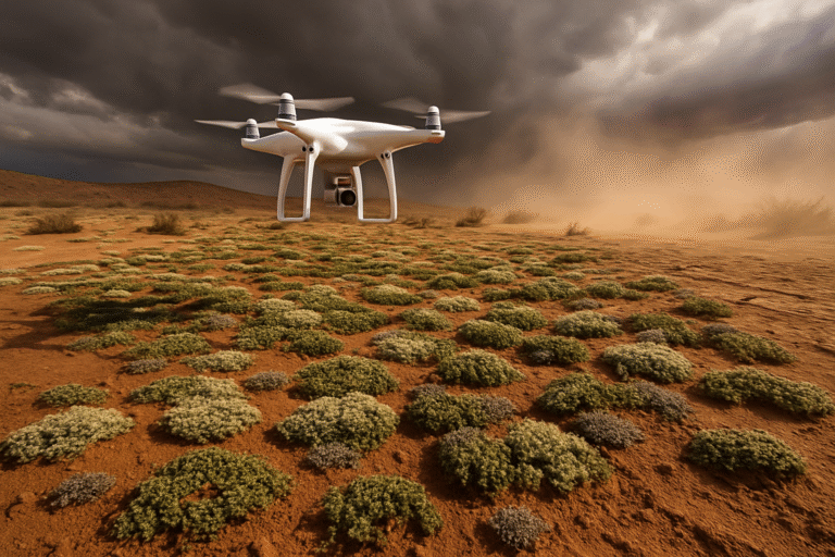
Once relegated to hobbyists and cinematographers, drone platforms have matured into rugged scientific instruments. Payloads that once weighed over ten kilograms now fit on drones smaller than a briefcase, drawing on lightweight composite materials and power-dense batteries. Multispectral cameras reveal chlorophyll activity in leaves, helping map areas of drought stress or invasive plant outbreaks. Hyperspectral units detect subtle chemical signatures in soil and water. Meanwhile, thermal imagers pierce nighttime darkness to locate nesting sea turtles, roosting bats, or secretive carnivores. The sheer versatility of these systems has unlocked new possibilities in regions where ground access is difficult and traditional aerial surveys are cost-prohibitive.
In East Africa’s savannas, conservationists have deployed fleets of drones to track elephant herds over thousands of square kilometers. By combining high-resolution imagery with machine-learning models trained on thousands of labeled photographs, software can count individual animals, determine age classes, and even detect poaching camps hidden in acacia groves. Automated alerts triggered by unauthorized human activity allow rangers to respond faster than ever before. In one recent operation, infrared drone footage guided response teams to dismantle an illegal snare-making workshop before a single animal was harmed.
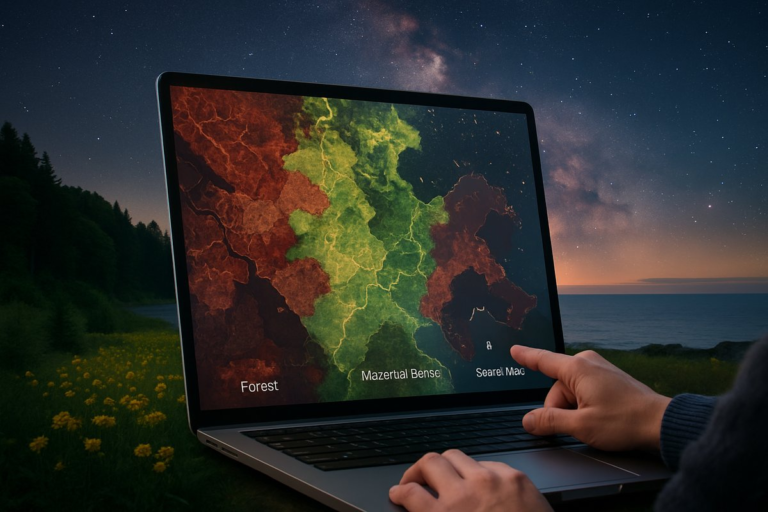
Beyond wildlife counts, drones are mapping landscapes in three dimensions. Lidar-equipped platforms pulse lasers downward to measure the height and density of vegetation, revealing the structure of tropical forest canopies or the contours of eroded riverbanks. This granular view informs restoration efforts by pinpointing degraded areas that need reforestation, guiding tree-planting teams to the most critical spots for carbon sequestration. In coastal wetlands, drones monitor saltmarsh expansion and shoreline erosion at intervals of just months, enabling managers to adjust sediment restoration projects in near real time.
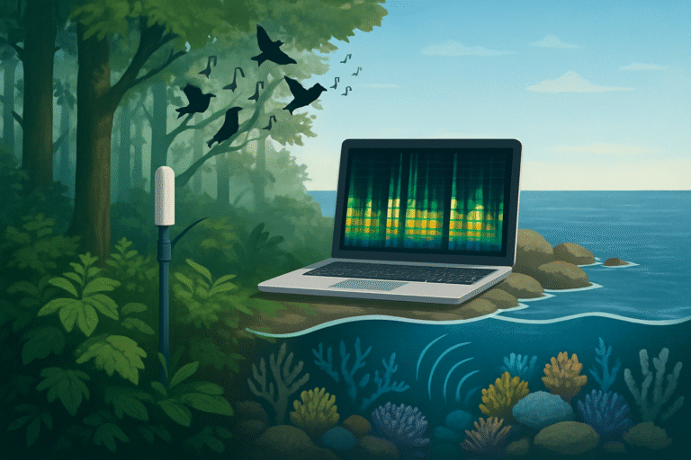
Artificial intelligence is the engine powering this aerial revolution. Deep-learning networks sift through terabytes of data to identify species, classify plant health, and flag potential threats. When a drone’s thermal feed detects a heat anomaly, a cloud-based algorithm can compare the pattern to a library of known animal shapes, distinguishing between deer, boar, or predators like coyotes. This automation reduces human error and frees up biologists to focus on higher-level analysis. In one pilot program, a partnership between a conservation NGO and a tech startup succeeded in cutting image-processing time in half, turning days of manual review into hours.
The benefits extend far beyond efficiency. Drones minimize human disturbance in sensitive habitats. Ground teams once needed to trek through nesting beaches or remote wetlands, risking trampling vegetation and altering animal behavior. In contrast, small electric drones emit little noise and no exhaust, allowing wildlife to behave naturally under observation. This noninvasive approach yields more accurate behavioral data, critical for understanding breeding success, foraging patterns, and migration routes.
Yet with great promise come new challenges. Battery life limits flight times to under an hour in many cases, forcing teams to rotate packs and contend with charging logistics in the field. Emerging hydrogen and fuel-cell prototypes hint at longer endurance, but regulatory frameworks struggle to keep pace. Flight restrictions around protected areas, airports, and populated centers can hamper survey schedules. And while noise levels are lower than manned aircraft, loud propellers can still disturb sensitive species if drones fly too close.
To address these hurdles, researchers are exploring tethered drone systems that draw power from the ground via lightweight cables, offering continuous flight for persistent monitoring. Solar-powered fixed-wing drones with wingspans exceeding two meters can remain aloft for days, hugging stratospheric currents. Swarm robotics-teams of dozens of microdrones working in concert-promise to map entire watersheds in a single morning, though coordinating complex swarms brings its own technical demands.
Community engagement has become a central tenet of many drone-based conservation programs. In the Amazon basin, indigenous groups have participated in training workshops to pilot drones and interpret data, ensuring that local voices shape research priorities. In Southeast Asia, farmers use simple drone kits to monitor rice paddy health and detect pest outbreaks, blending agricultural resilience with biodiversity safeguards. By democratizing access to this technology, practitioners hope to shift conservation away from a top-down model toward a more inclusive approach in which citizens, scientists, and policymakers collaborate.
Data security and privacy also demand careful attention. High-resolution aerial imagery can reveal individual homesteads and infrastructure, raising concerns about sensitive cultural sites and community privacy. Responsible projects anonymize footage, limit data retention, and adhere to local permitting rules. Clear protocols for data ownership and sharing help build trust with on-the-ground stakeholders.
The narrative arc of drone-driven conservation is still unfolding, but early successes are already influencing policy. Governments are crafting drone-friendly regulations for environmental research, carving out special aviation corridors for scientific flights. International bodies are standardizing data formats to facilitate global biodiversity monitoring networks. This growing institutional support paves the way for integrated systems that combine satellites, manned aircraft, ground sensors, and drones into a cohesive observation grid.
Beyond traditional conservation, drones are branching into new frontiers. Fire-watch systems in California’s chaparral biome use thermal imagery to detect hot spots before they erupt into uncontrollable blazes. In the Arctic, drones equipped with methane sensors are racing to track greenhouse gas leaks from thawing permafrost. Marine researchers are testing submersible drone hybrids that can alight on the ocean surface and dive to map coral reefs in three dimensions.
A powerful byproduct of these developments is public engagement. Captivating drone footage shared online deepens public empathy for distant ecosystems and vulnerable species. Virtual reality experiences built from drone imagery let students explore remote rainforests or witness elephant herds migrating across the Serengeti. This emotional connection can translate into support for conservation funding, sustainable policies, and community stewardship.
As the technology evolves, collaboration between engineers, ecologists, ethicists, and local communities will be essential. The goal is not to replace traditional fieldwork, but to enhance it-yielding richer insights while respecting the rhythms of nature. By combining human curiosity and care with aerial innovation, drone platforms are becoming indispensable partners in safeguarding the planet’s biodiversity.
In the years to come, drones may carry ever more sensitive chemical sensors to detect pollutants in real time, or miniaturized spectrometers to identify harmful algal blooms in freshwater lakes. They could guide reforestation projects by delivering seed pods directly into deforested clearings or ferry emergency supplies to rangers in remote outposts. What remains constant is the spirit of possibility: a new generation of conservation tools born from the marriage of cutting-edge technology and a deep reverence for the natural world.
The silent hum of a drone wings overhead may seem unremarkable at first. Yet each flight is a step toward more informed stewardship, enabling us to see ecosystems from fresh vantage points and respond nimbly to emerging threats. In an era of rapid environmental change, these eyes in the sky offer hope that we can observe, understand, and protect the intricate web of life that sustains us all.
From mapping murmurations of starlings at dawn to tracking sea turtles under moonlit tides, drones have opened windows into realms once hidden from human view. As the technology soars to new heights, it invites us not only to gather data, but to deepen our empathy for the living landscapes we share.